Hi all,
It took a few hours, but I have the Western and Eastern US Maps done. Only the Eastern Canada Map to go and we will be up to date. If you are in the US, take a look at your tack and make sure I got it right.
For those new to the forum, the map link on the Home Page at gogodiablo.com is a tool to see who around your area have Hus Skis and Diablos. The tacks are located in the general area of where people live and are not placed directly on their addresses. We had one map for all tacks last year, but with knowing over 270 people who had Hus Skis and Diablos, the map function got full and we were not able to add.
Then along came Super Joey (my oldest son who knows a heck of a lot more about websites than I do) and fixed the map so we can look at it in regions and hopefully, we will not fill up the map to a point where tacks start disappearing.
It was a cool weekend in Wisconsin. Weather down in the 40's at night. Almost like fall is here and that can only mean winter is not far behind. It's time to start thinking of locations for our 4th Annual Hus Ski / Diablo Get Together. If you have ideas, let me know. Before the end of September, I'll send a note out to all asking for suggestions.
Bruce
9/6/10 Rest of the US Map Chat
-
Go Go Diablo
- Site Admin
- Posts:1838
- Joined:Fri Feb 22, 2008 12:47 am
- Location:Sobieski, Wisconsin
- Contact:
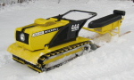
Too many Diablos and parts to count.
Yamaha 600 SX
Yamaha 600 SX
-
Barrie2777

- Posts:1547
- Joined:Tue Mar 04, 2008 9:17 pm
- Location:Arundel Quebec
Re: 9/6/10 Rest of the US Map Chat
Maybe the crank on the side of my computer doesn't allow for maps to download but when I go to the "MAP" section all I get is a "Google maps" map...no tacks. The map is of the entire North American continent. Incedently, the maps shows the "north Atlantic" to be east of Florida.....what do they call it at the longtitude of Newfoundland? and something in Canada's great white north described as "northwest Passages". How long ago was this map drawn!!!??? Maybe it is a handsketch of one of Samual de Champlain's original navigation maps.
Re: 9/6/10 Rest of the US Map Chat
You have to click on the particular area that you want to view, then zoom in with the + sign. When clicking on a particular area, you have to move the cursor around a bit until the picture of the hand comes up, then click.